
News
Harford County Government
Master Plan Series
Harford County Government is working with a consulting group to engage with the public over the next 8-10 months to help inform the next Harford County Master Plan. Also known as ‘comprehensive plans’, these substantial documents, produced about every ten years, guide land use, housing, infrastructure, transportation and more.
Stay tuned to our series to keep up with the Master Plan Process.
Topics
The Cost of Expanding the Development Envelope
Subscribe To Our Newsletter
Be the first to see our posts on the Master Plan, along with upcoming events and conservation news. Your contact information is kept confidential and you’ll get our occasional updates directly to your inbox.
The Cost of Expanding the Development Envelope
September 17, 2026
As was recently reported in the Aegis, 86% of Harford County’s Development Envelope is either developed or undevelopable, leaving room for an estimated 11,705 homes. It begs the question: Should we expand the envelope’s boundaries? And would doing so hurt or harm our economy, environment, and quality of life?
Put simply, there are no planning, environmental, or economic justifications for expanding Harford County’s Development Envelope.
Designated in Harford County’s 1977 Comprehensive Plan, the Development Envelope (also known as an urban growth boundary) is designed to contain development to areas planned for public water and sewer while discouraging development in the wide-spread rural areas. Since its inception, its boundaries have grown through Master Plan recommendations, municipal annexations, and zoning changes. Refer to HLT’s July 2026 blog for more introductory information on the Development Envelope.
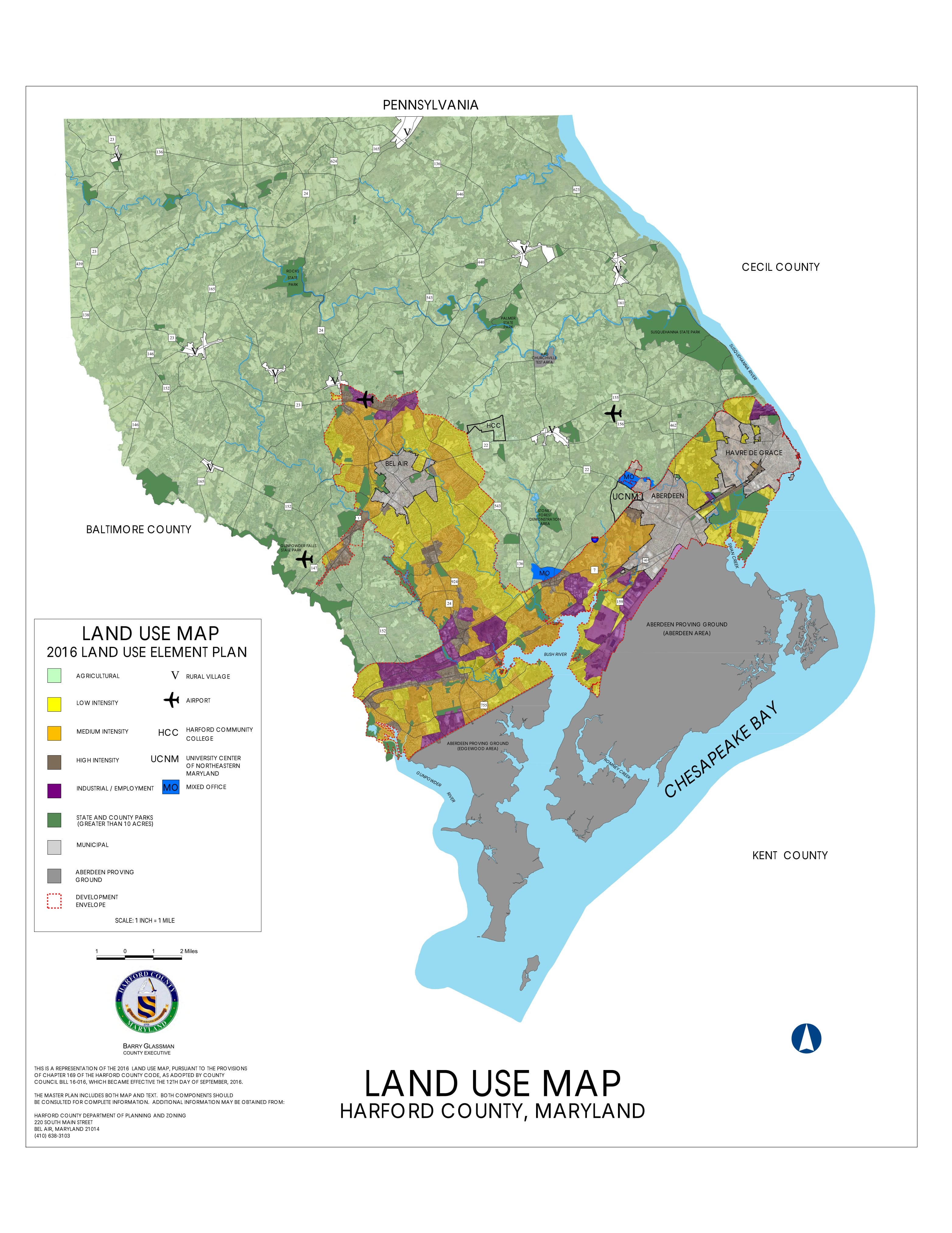
Harford County Government recently launched a website and opened public comments for the drafting of the next Master Plan, ‘Harford Forward.’ This plan will contain a “Land Use Element Plan” map that specifies the Development Envelope boundary and designates blocks of land use types such as Agriculture, Low Intensity Residential, Medium Intensity Residential, High Intensity Residential, Industrial/Employment, Rural Villages, and Parks greater than 10 acres.
Cost of community services
The county’s ability to properly maintain its existing stormwater, water, sewer, and road systems is already stretched. Add to that schools, libraries, police, and other services. Extending such infrastructure and services into rural areas only deepens the gap.
The Development Envelope corresponds to the Harford County’s Priority Funding Area (PFA), or areas where the county focuses assistance from the state for growth, like highways, infrastructure, and economic development assistance. Expanding the envelope’s boundaries could strain state funding designated for the area. The services and infrastructure required to serve a larger envelope could outgrow what Harford’s state assistance has the capacity to pay for, leaving County Government to foot the bill.
As a tool to consolidate public water and sewer, major roads, and public utilities, maintaining the Development Envelope’s boundaries (and enforcing those boundaries in construction permitting) saves the Harford County taxpayer money. A 2004 Cost of Community Services Study from the American Farmland Trust found that residential homes require $1.11 in public services for every dollar they contribute, while farms only require $0.91 for every dollar.
Each expansion of the Development Envelope means more costly community services, where those tax dollars could be better spent improving existing infrastructure so that it can function more efficiently in larger population centers. And besides helping the county save money, it also helps the county make money, by protecting its key industries that depend on natural resources outside the envelope.
Environment and agriculture
Farming is the second largest industry in Harford County. In 2022, Harford County farms made almost $66 million in sales, and 320 of the county’s 1,190 producers were new or beginning farmers, according to the Census of Agriculture. Farming is not just a prevalent industry but also significant opportunity for economic growth.
However, between the 2017 Census of Agriculture and the 2022 Census, Harford County dropped from 628 farms to 613 and lost over 8,300 acres of farmland. The county’s average farm size dropped 9%. The authors of the 2016 Master Plan called ‘HarfordNEXT’ attributed this negative trend to development pressure occurring outside the Development Envelope.
The Development Envelope is also one of the county’s best tools for controlling land fragmentation. Large, contiguous blocks of land are crucial for providing plants and wildlife with the space they need to thrive. These corridors provide buffers for sensitive habitats, filter nutrient runoff before it can reach our waterways, and host amazing recreation opportunities for residents and visitors of Harford County.
As land is subdivided into smaller and smaller parcels, and as forests are broken up by sprawling developments, these corridors fracture, compromising the benefits they can provide for people and ecosystems. Containing development to the urban growth boundaries helps protect the few remaining untouched tracts and creates a better chance that more can be connected and preserved.
Housing and redevelopment
There is room to grow without moving the line. Harford Forward will need to focus on vacant lots and buildings and redevelopment opportunities. Suburban retrofits can help meet the demands for smaller homes and affordable multifamily housing that fit within existing neighborhoods.
Concentrating development incentivizes communities that are more walkable, placing homes closer to grocery stores, community centers, parks and other resources. A great example is the recent redevelopment of the Harford Mall into housing units where a previously impacted plot of land could be repurposed into a residential and economic growth area.
As you submit your public comments on the new Master Plan website, make sure to speak up for maintaining the Development Envelope’s boundaries. It’s one of our strongest tools to keep our economy, residents, county budget, and local environment thriving into the future.
Public input opportunities now open
July 16, 2026
Harford County Government has officially launched a new website to serve as a hub of information and community engagement for the county’s next Comprehensive Plan, also known as a Master Plan. The site features an online survey where you can speak up about how you want to see the county move forward, and also lists events where you can give input in person.
Starting sometime after summer, staff from the Harford County Department of Planning and Zoning will also be presenting about the Master Plan at local Community Advisory Board (CAB) meetings. Keep an eye on your local CAB’s schedule and agenda notices to find Master Plan discussions in the coming months.
A larger public engagement report is expected to go into development in early 2027, but periodic, preliminary public engagement reports have already been released on the Harford Forward website. In the August analytics report, 12.93% of respondents listed ‘Parks / Open Space’ as their answer to ‘What are Harford County’s greatest strengths?’ It was the top selected answer, and not far behind was ‘Agricultural Preservation,’ which came in at 11%.
This theme persisted throughout the following section, where citizens could provide specific answers about what they considered the county’s greatest strengths. Answers like hiking trails, small town charm, locally grown produce, proximity to quality parks, clean air and water, access to the Chesapeake Bay, and scenic outdoor spaces, were highly prevalent.
For the next question, ‘What are the most pressing challenges facing Harford County today and in the future?’ the answers followed a similar logic. Prevalent among these concerns are over development, expansion of the Development Envelope, loss of agricultural land to energy infrastructure, loss of open space, and traffic congestion due to poorly planned developments.
It’s clear that many communities in Harford County cherish and depend on local open spaces. Near the top of the survey, people cited ‘rural character’ and ‘agricultural community’ among the top reasons they lived here. ‘Rural character’ was second only to ‘close to family/friends.’
The Master Plan plays a significant role in balancing sustainable development with land and agricultural preservation, helping ensure that we can count on a thriving environment and local produce while meeting community needs. While these plans are often better known for their guidance on topics such as housing, transportation, and public utilities, they also set many of the goals that help direct land preservation and environmental conservation efforts. Two of the plans eight topic are dedicated to strengthening our ecosystems and local food production: Natural Resources; and Agricultural Preservation.
Additionally, the Master Plan coverage of economic development, housing, and transportation, sets a road map for where and how development will be prioritized in the county. These topic areas can serve as a tool to protect the farms, forests, waterways, and ecosystems that Harford County residents depend on by concentrating future growth inside the development envelope, and maintaining the envelope’s boundaries.
Submit you comments today, and make sure to share why Harford County’s open spaces and natural resources are important to you, and why we should prioritize protection of these irreplaceable places.
What is the Development Envelope? And how does it shape county planning?
July 16, 2026
Planning doctrine tells us that uncontrolled growth is inevitably destructive. Such sprawl occurs sporadically in the places that maximize private gain rather than overall public benefit until the landscape is irreversibly spoiled (in other words, death by a thousand cuts).
Like most counties in central Maryland, Harford County adopted numerous growth management measures in the 1970s and 1980s in response to a large-lot subdivision boom, loss of agricultural land, and local government budget strain.
Designated in 1977, Harford County’s Development Envelope (also known as an urban growth boundary) is designed to contain development to areas planned for public water and sewer while discouraging development in the wide-spread rural areas. It’s generally defined as the area along the MD 24/MD 924 corridors and the Interstate-95 US 40 corridors, including Bel Air, Aberdeen, and Havre de Grace, and it’s often referred to as an “inverted T” due to it’s shape. At the same time, agricultural zoning allowing one house for every 10 aces was adopted.
The Development Envelope is intended to continue as Harford County’s main residential and commercial growth area, accommodating most of the county’s increasing population and economic activity for the foreseeable future. Advantages of growth boundaries include:
- Clearly shows where growth is intended.
- Creates specific limits of public water and sewerage, major roads, and other public infrastructure.
- Communicates predictable development patterns to private landowners.
- Encourages rural landowners to protect their land with conservation easements.
- Facilitates county and municipal planning cooperation
- Assists in designating State planning areas (Priority Funding Areas, Priority Preservation Areas, etc)
- Supports revitalization of older developed areas and encourages infill development.
The Development Envelope has been largely effective at concentrating growth. In 2025 approximately 92% of the 659 new residential permits (County and Municipal) were located within the Harford County’s Development Envelope, according to the county’s 2025 Annual Growth Report. There is an estimated capacity of 11,705 residential units in the Development Envelope remaining.
However, the boundaries of the Development Envelope and municipalities aren’t fixed and they have changed over the past 50 years.
Harford County’s 2016 HarfordNEXT plan contains a “Land Use Element Plan” map. This map specifies the Development Envelope boundary and designates blocks of land use types such as Agriculture, Low Intensity Residential, Medium Intensity Residential, High Intensity Residential, Industrial/Employment, Rural Villages, and Parks greater than 10 acres. Municipal and Federal (Aberdeen Proving Ground) are also delineated.
The Land Use Element Plan is arguably the most consequential component of Harford County’s comprehensive plan. The plan guides the eight year Comprehensive Zoning Review cycle and the Master Water & Sewer Plan. However, the Development Envelope is referenced in some but not all related parts of the Zoning Code (in fact the Development Envelope is referenced only 18 times in the 400+ page document).
In 2025, the County Council voted to change the zoning on numerous parcels that was inconsistent with the Land Use Element Plan. When up-zoning happens or unplanned extension of services happens just outside of the Development Envelope (for example, the James Run development at Route 543 and I-95), it is often followed by an inevitable bumping out of the boundary during the next comprehensive plan.
Additionally, while some Maryland counties and municipalities have mutually agreed upon annexation limit lines or growth boundary memoranda of understanding, Harford County does not. Since 1997, Aberdeen has annexed more than 350 acres north of I-95, and Havre de Grace’s northwestern boundary is also butting up against the edge of the development envelope.
About 86% of the Development Envelope is developed or undevelopable, according to Harford County Government, and we are experiencing pressure to expand it’s borders. But land is finite, so we cannot expand the Development Envelope infinitely. So what do we do now?
Stay tuned to our blog series to learn more. We’ have more coming about the public input opportunities for the Master Plan, the plan’s coverage areas, and it’s implications for the Development Envelope.
The gears are now turning to produce the next Harford County Master Plan.
June 18, 2026
Harford County Government has hired and started working with a consulting group to engage with the public over the next 8-10 months to help inform the next Harford County Master Plan. Also known as ‘comprehensive plans’, these substantial documents, produced about every ten years, guide land use, housing, infrastructure, transportation and more.
Known in the 2016 iteration as “HarfordNEXT,” the updated plan will be renamed and tentatively includes eight focus areas: 1. Housing Affordability; 2. Transportation & Mobility; 3. Water Resources & Climate Resilience; 4. Economic Development; 5. Strong Communities; 6. Public Safety; 7. Agricultural Preservation; and, 8. Historic Preservation.
Master Plans spell out the manner in which a county must develop. They typically include a map showing proposed future land use and anticipated transportation and community facilities. Plans also contains policies for protecting environmental features and recommendations for amending local development-related ordinances in a manner that helps achieve the comprehensive plan’s objectives. They must also explain how the jurisdiction will provide water for development and address the handling of sewage treatment plant discharges. Master Plans have legal significance in that zoning, provision of water and sewer, and other local actions must be consistent with its recommendations.
A Harford County Master Plan website will be live soon. The site will serve as a informational hub, including an online survey and listing of in-person opportunities to provide citizen feedback.
We will keep you informed about the details of the plan as they arise through an ongoing series. Return to this article, sign up for our newsletter, and follow us on Instagram and Facebook for updates.